A photo lands in your tip line. A private jet on a tarmac. A commercial airliner behind it. Dry grass, a flat horizon. The caption claims one airport. Your editor wants it in the next hour.
Is it real, and was it taken where they say?
Get it wrong and you have amplified a hoax. The verification tax on every visual story used to cost hours of manual OSINT work. Here is the same job in under two minutes, with an evidence chain you can publish.
The professional standards
Newsrooms and OSINT investigators have been verifying photos for over a decade. Oceanir automates the Location pillar. The rest (provenance, source, date, motivation) still require editorial judgment.
Provenance, Source, Date, Location, Motivation. Provenance matters most.
Identify, collect, preserve, verify, analyze, review, present.
24/7 monitoring, OSINT geolocation, origin tracing, rights clearance.
AI-assisted dashboard for geolocation, landmark detection, reverse search.
Three tiers: verified, believed genuine, unverified.
Step 1. The image, cold
No caption. No metadata. No EXIF. Oceanir never uses it. The location has to come from the picture itself, the same standard a skeptical reader would hold you to.
Instagram, Facebook, X, Telegram. They all strip EXIF on upload. If your verification depends on embedded GPS, it fails on the exact images that land in a tip line. Oceanir works from visual content alone.


Step 2. What the image tells you
Every claim is tied to a cue you can point at. Five independent evidence categories converge on the same place. The professional standard requires three. Oceanir gives you five.
Every cue is falsifiable. A reader can check the tail number. A source can dispute the vegetation. That is what makes it verification.
Evidence Funnel
Five cues narrowing to one location
Visual cues extracted
Tail number, livery, vegetation, fencing, shuttle
Country + region locked
N-registration, scrub oak biome
City + site confirmed
Coastal field, commercial service, KACK
Precise location
Apron perimeter, high confidence
Step 3. From cues to a place
The cues narrow the answer one confidence tier at a time. A black-box pin on a map is not enough. The desk needs the reasoning chain.
Confidence Tiers
How the cues narrow the answer
(N-registration)
(scrub oak / pitch pine)
(coastal field + summer)
(KACK)
(high, not certain)
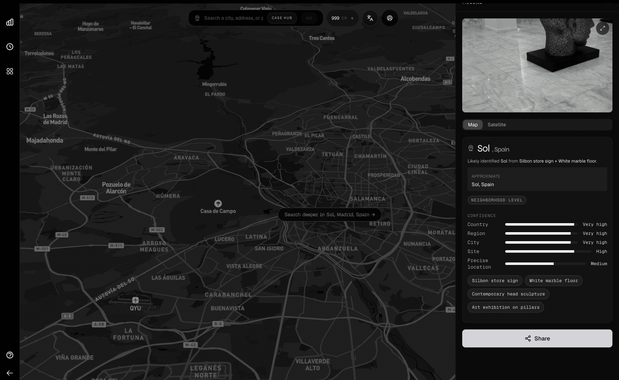
Result: Nantucket Memorial Airport (KACK), Nantucket, MA.
Precise location is High, not Very High. A tool that claims 100% on everything is lying to you. The value is knowing exactly how far the evidence carries, and where it stops.
How tiers map to editorial practice
Step 4. The check
Satellite and 3D of Nantucket Memorial Airport line up against the source cues. Apron layout, perimeter fencing, scrub line, seasonal ramp operation. This is the part that goes in the story. A documented chain from a visible detail to a place a reader can retrace.
Street View is not shown. Airport tarmacs have no interior coverage. Satellite and 3D are the right check for restricted-access sites. A Bellingcat investigator would make the same call.
Step 5. Provenance
Location is half the job. The other half is provenance. Is this the original image, or has it been recycled and miscaptioned?
If the caption claims yesterday but the earliest indexed appearance is 19 months old, on a regional news site with a different caption, that is an immediate red flag. Reuters used this technique to debunk a "Maui wildfire" video that was actually a 2022 mulch fire in Cleveland, Ohio. AFP used it to trace "Iranian nuclear site" footage to tourist attractions in Nicaragua and Saudi Arabia.
This turns a one-time verification into an ongoing intelligence feed. If the photo resurfaces with a new caption, the desk knows within hours.
Verification timeline (90 seconds)
Time to defensible location
Manual OSINT vs Oceanir (log scale)
Time reduction
99.9%
Human vs Oceanir
The same verification job, side by side
Save image, check EXIF. Stripped? Move on.
Image received. No EXIF needed.
Google Lens, Yandex, TinEye reverse search. No hits.
Visual cues extracted automatically.
Read the image. Note tail number, vegetation, fences.
Five cues identified and categorized.
Search tail number on FAA registry. Confirm U.S.
Country locked. N-registration.
Cross-reference vegetation with ecology maps.
Region locked. Scrub oak, pitch pine biome.
Search coastal airports with commercial service.
City and site confirmed. KACK.
Open Google Earth. Walk satellite imagery by hand.
Satellite and 3D cross-check automated.
Document findings. Write up evidence chain.
Evidence chain generated automatically.
Measured outcomes
Manual workflow
4 to 6 hrs
Senior analyst walking Street View, cross-referencing satellite imagery by hand.
With Oceanir
under 90 sec
Same evidence chain, same defensible standard, delivered to the desk.
Independent anchors
5
Exceeds the three-anchor threshold for publication-grade verification.
Verification is showing your work. That is the difference between a tool that geolocates and a tool a newsroom can stand behind.
Real cases where geolocation caught a hoax
Oceanir automates the core of this work. The editorial judgment remains human.
Social posts claimed a video of flames showed the 2023 Maui fires.
Outcome: Miscaptioned. The clip showed a 2022 mulch fire in Cleveland, Ohio.
Method: Geolocated visible signs using Google Street View. Traced a ViralHog YouTube upload.
A viral compilation was falsely described as Iranian nuclear sites.
Outcome: False context. Clips were from tourist sites in Nicaragua and Saudi Arabia.
Method: Reverse image search of keyframes, source-account tracing, Google Maps comparison.
A far-right fight night event was posted on Telegram.
Outcome: Confirmed the venue as Fuhrmann Hall, Heritage Park Events Center, Muenster, Texas.
Method: Matched a US flag, MVFD table marking, ceiling, windows, and doors against venue results.
A video allegedly showed a Buk launcher in Snizhne after MH17.
Outcome: Confirmed the route and vantage point, placing the launcher 10 to 15 km from the crash site.
Method: Matched road geometry, trees, junctions, and a red-roofed house against Google Earth.
Sources
- First Draft News. Verifying Online Information. The five pillars.
- Bellingcat. Beginner's Guide to Social Media Verification and J&A Manual.
- Reuters. Verification Services. UGC with rights clearance.
- Associated Press. AP Verify (2025).
- BBC. Editorial Guidelines: UGC. Verified, believed genuine, unverified.
- EBU Spotlight. Investigative Geolocation and Advanced GEOINT.
Run your own image
Upload an image and get a defensible location with a documented evidence chain in minutes.