Where is this building? Identifying it from one photo
Someone sends you a street photo and asks where it is. Here is the method, worked through on one real London photo: name the building, confirm the city with a clue that has nothing to do with the building, narrow the area, then say plainly what the photo cannot prove.
Step 1
Start with the shape no other building has
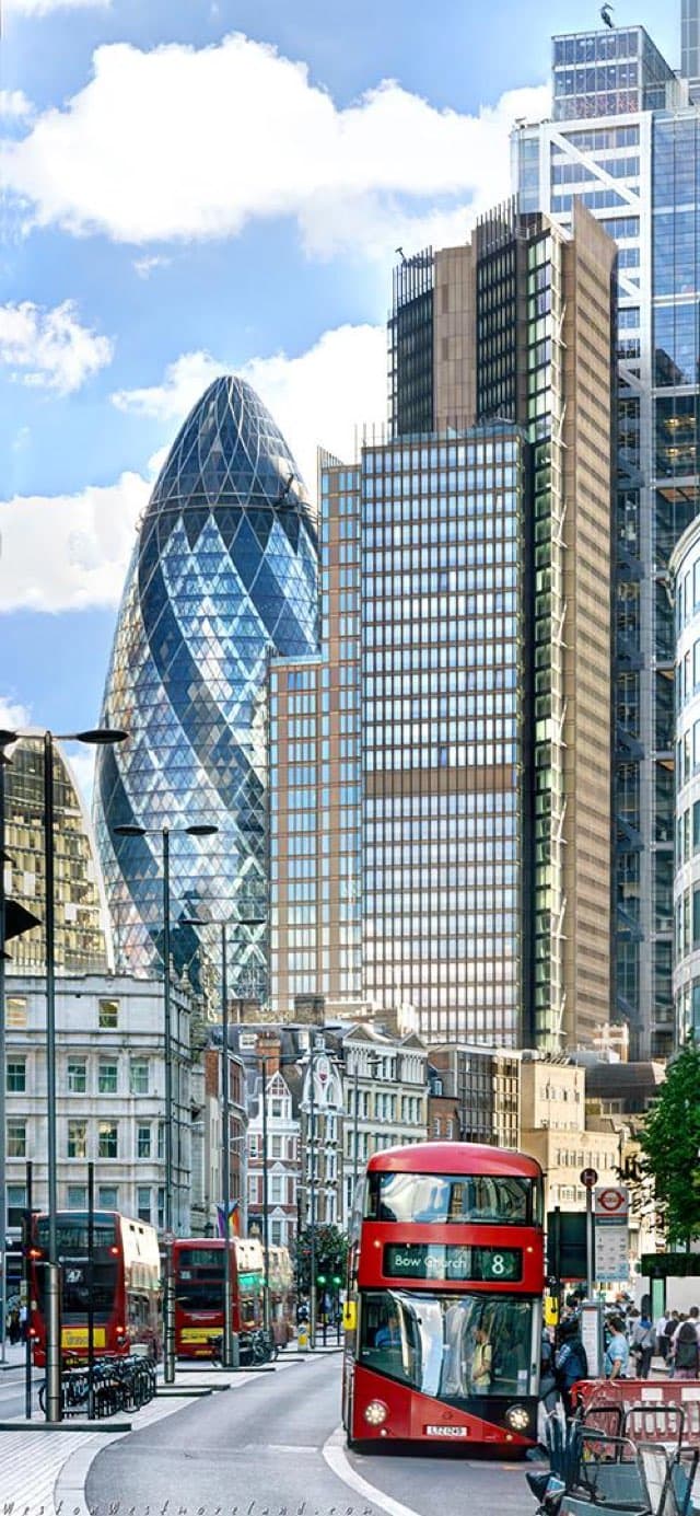
The rounded glass tower with a diagonal grid and dark spiralling bands matches 30 St Mary Axe, the tower known as the Gherkin, in the City of London. Very few towers have this outline, which is exactly what makes it useful. A plain glass box would tell you almost nothing.
How to check: Compare the window grid and the dark bands, not only the silhouette. Barcelona's Torre Glòries has a similar bullet shape but a completely different skin, so the pattern matters more than the outline.
Step 2
Confirm the city with a clue that is not the building
The red double-decker in front shows Bow Church and the number 8 on its destination blind. That is a London bus route, and Bow is in east London. A landmark can turn up in a poster, a reflection or an edited image. An everyday detail like a bus blind is much harder to get wrong by accident.
How to check: Look up the route number and destination on the operator's route map. If the route never runs near the building, one of your two clues is wrong and the answer is not settled.
Step 3
Read the street, not just the skyline
A bus stop sign stands on the right pavement and a row of docked hire bikes runs along the left. Tall street lamps line a wide road that curves away from the camera. Each detail is common on its own. Together they describe a main road in central London rather than a quiet side street.
How to check: Write down what kind of street it is before you open a map. It stops you from forcing the photo onto the first street that shows the same landmark.
Step 4
Use the building's size to estimate distance
The Gherkin is about 180 metres tall. In this photo its lower floors are hidden behind older buildings and it fills well under half the frame, so the camera is a few hundred metres away, not at its base. That turns "somewhere near the landmark" into a ring of streets you can actually check.
How to check: Compare how much of the building is visible with how much is hidden. A tower seen whole from base to top usually means a wide open view or a long distance.
Step 5
Use the other towers for direction and date
From any one viewpoint, the taller towers on the right keep a fixed order and overlap with the Gherkin. Matching that arrangement tells you which side you are looking from. The City skyline also changes fast, so the set of towers in view gives a rough earliest date for the photo.
How to check: Compare the order of the towers, left to right, with a recent skyline photo taken from the same side of the building.
What this photo cannot prove
The exact spot
The Gherkin can be seen from dozens of streets. The clues above get you to a district and a direction. Matching the street-level view is what confirms where the camera stood.
When it was taken
Beyond a rough range from which towers exist, a photo like this does not carry a reliable date.
That it is unedited
A building can be pasted into a scene. Check that shadows, reflections and haze agree across the whole image before trusting any clue.
Run the same check on your own photo
With a free account, Oceanir gives a city-level estimate from the image alone. A detailed check compares candidate areas with street-level and satellite imagery and shows the clues for and against each place, so you can see why it was picked instead of taking a pin on trust.
Try this photo or upload yoursQuestions
- How do I find where a building is from a photo?
- Name the building if its shape is distinctive, confirm the city with an unrelated clue such as signs, transit or number plates, estimate the distance from the building's size, then match the street-level view. If the building is ordinary, lean on the street details instead.
- What if the building isn't famous?
- Most buildings aren't. Signs, shop names, road markings, street furniture and the shape of the road usually carry more location information than an ordinary facade. A photo of a plain wall or an interior may honestly stay unresolved.
- Can you find the exact address of a building from a photo?
- Sometimes, for public places with enough street detail in the frame. Oceanir does not locate private homes, and a city or district answer is often the honest result for a single photo.
- Is there a free tool to identify a building from a photo?
- Yes. With a free account, Oceanir gives a city-level estimate from the image alone. Street-level checks against reference imagery are part of paid analysis.
Try the sample. Check the answer.
Choose the sample button to run this photo, or upload your own image. The scan uses the image; the known city is shown here for your comparison.
Compare the returned city and map with the known location. A confidence score is a model estimate, not proof that the answer is correct. If the result disagrees with the visible clues, keep it unresolved.
The free scan does not establish an exact address. You can continue with the same image in the workspace to inspect candidates and available reference imagery before deciding whether to use paid analysis.
Try a free location check. Usage limits apply; sign-in may be required. Your photo stays attached.